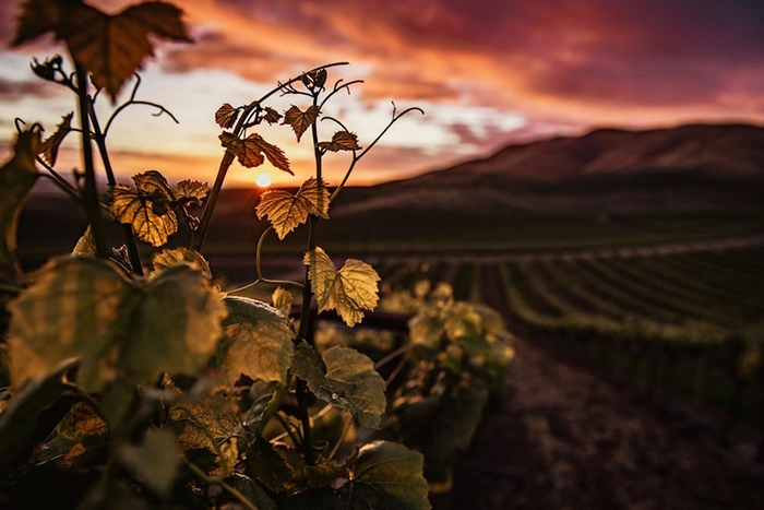
Going to Lajares and walking along one of the trails that border this town is something that we should do more often.
If you put aside your sneakers, because you got tired of visiting the same places, today we suggest you take one of the most beautiful excursions you can do near Corralejo. Put on your goretex boots again, take your trekking poles, and come and spend a different day going up to Calderón Hondo!
Before talking about the various routes enabled to reach the Calderón Hondo, we will give you some clues about its history, and about the biodiversity that you will find throughout the route.
Where is the Calderón Hondo?
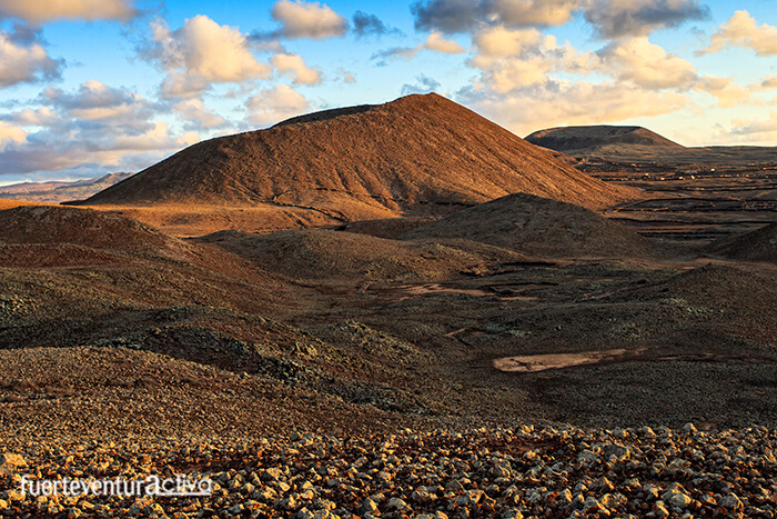
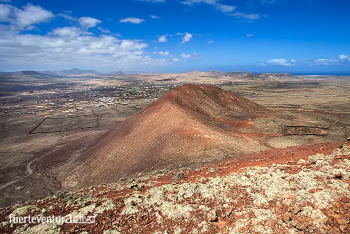
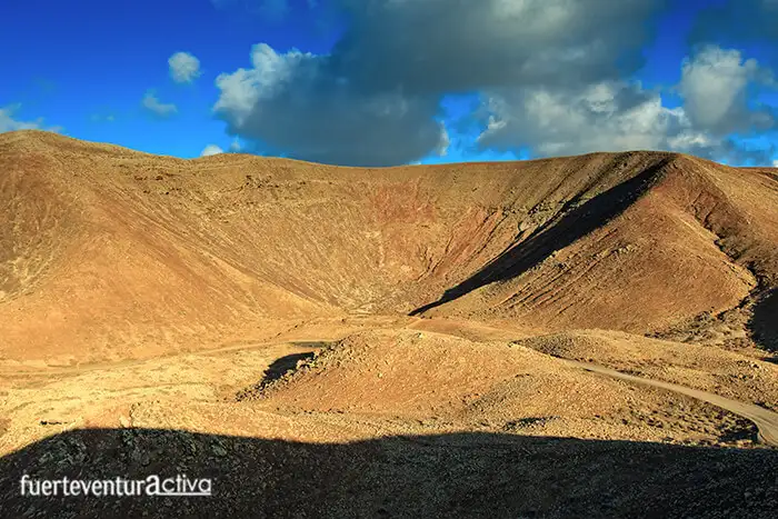
The Calderón Hondo is one of the most representative volcanic cones in the municipality of La Oliva. It is located north of Lajares, and is linked, by a small hill, to Montaña Colorada, another volcanic cone, this one of lesser importance.
The Calderón Hondo is part of the Bayuyo line-up.
If you look to the north of Fuerteventura, from the Googlemaps, you will clearly appreciate that all the volcanic cones that go from Isla de Lobos to Montaña Colorada follow the same straight line. Those 8 circular cones and calderiform craters form the Bayuyo alignment. They erupted at the same time, about 135,000 years ago.
Fauna and flora around the Calderón Hondo
This part of Fuerteventura is characterized by the predominance of mountains of warm tones, bare of vegetation. Although throughout the tour you will see tabaibas, verodes, tuneras, and thorns, the floristic importance of the Calderón Hondo is given because the cuernúa or diente de perro lives here, a threatened, protected and classified as “vulnerable” species.
The space that surrounds the Calderón Hondo is an important area for ornithological observation. The guirre, the Canary crow, the hawk and the kestrel, live in perfect harmony with other smaller birds such as the Canary stonebird, the shrike, and the trumpeter bullfinch, among other species.
How to get to Calderón Hondo?
There are two main routes to access the Calderón Hondo. One of them, the most affordable, is just 3.7 kilometers long, and starts from Lajares. The other route leaves from Corralejo, and has a distance of just over 9 kilometers.
Lajares - Calderón Hondo Route.
This route is called "SL-FV-2 Lajares-Calderón Hondo". It is very well signposted. In it, there are several viewpoints and informative posters where, in addition to offering you curiosities of the area, they will guide you all the way.
The round trip, with 2 rest stops, takes about 2 and a half hours. It is a route suitable for all ages and physical conditions.
To find the beginning of the route, you have to take the road that connects Lajares with Majanicho, which begins at the Lajares Municipal Football field.
Almost 1 kilometer from the football field. On the right-hand side, there are the marks of the Natural Paths Network of Fuerteventura, which indicate the route to follow. This is also a good place to leave the vehicle.
The first landmark that we will see is Montaña Colorada. From afar you can see the footprints left by an illegal quarry of picón installed on its slopes.
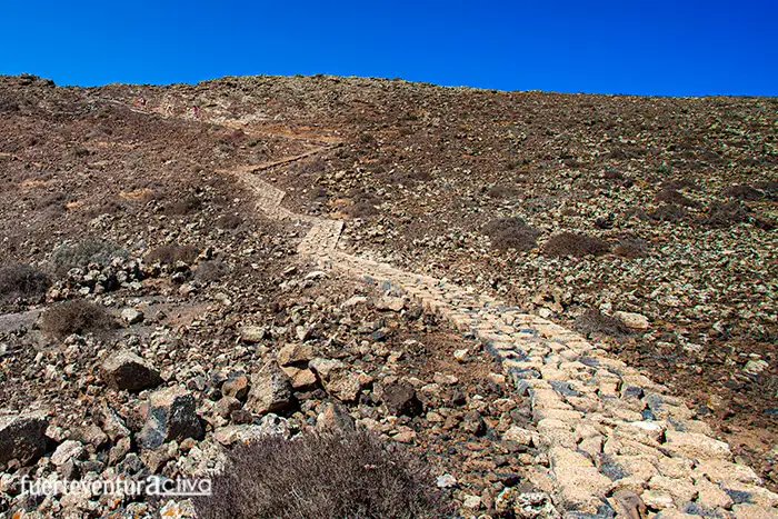
About 3 kilometers from the start of the route, you will have already arrived in front of a sign that indicates the way to follow to access the Calderón Hondo viewpoint. The access, although short, is quite steep, however the effort will be worth it.
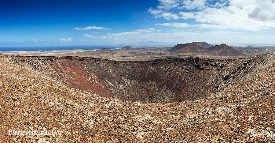
From the crown of the Calderón Hondo you have magnificent views of the North of Fuerteventura.
Part of the edge of the volcanic cone is protected with a railing. You will be able to look out to contemplate the perfect circular crater of the Calderón Hondo. It is 70 meters deep and 100 meters in diameter.
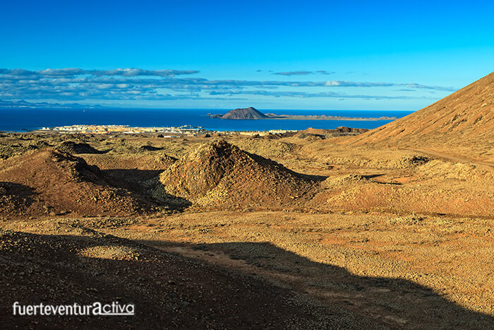
In addition, the Cabildo installed here, one of the 8 landscape binoculars that exist in Fuerteventura. This specifically looks from the Calderón Hondo towards the badlands of Bayuyo, Corralejo, Isla de Lobos and Lanzarote.
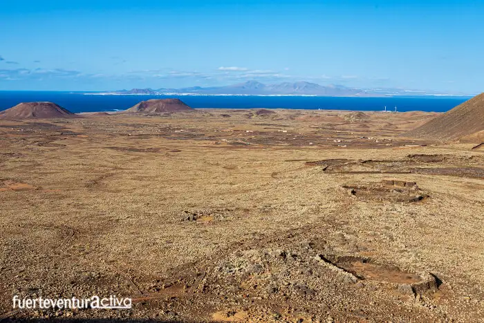
From this point, at about 278 meters above sea level, it can be seen how in the nearby badlands there are a large number of boundaries, shrimp and remains of residential buildings. Some of these constructions have more than 500 years of history.
Although the badlands may seem like an unwelcoming place to live, Bayuyo was inhabited since times prior to the Castilian conquest.
Let's not forget that Bayuyo was an enclave with magical and spiritual connotations for the mahos. They believed that, on the summer solstice, their ancestors returned to this area in the form of clouds.
The magnificent viewpoint, offered by the Calderón Hondo, allows you to see the remains of some ponds raised by the mahos to collect water.
Corralejo - Calderón Hondo directions
The path that connects Lajares with Corralejo is a wide dirt track. It is in good condition. It can even be traveled by bike or in a vehicle suitable for rough terrain. It is not strange to come across boogie excursions around these places.
This itinerary takes us through a spectacular landscape formed by the badlands. It is a unique way to discover the Bayuyo lineup. The winding route follows the slopes of the volcanic cones that make up this geological complex.
To start the route, look for the Corralejo football stadium. A little further up there is a roundabout that houses the sculpture of a ship, on whose sail different sports are represented. Go up the track that indicates “Morro Francisco”. A few meters away, take the second street to the right until you reach a municipal water tank.
This is where the hike really begins. First we will pass through the San Rafael Mountain, then we will find Bayuyo, Las Calderas, Caldera Encantada, Caldera Rebanada, and Calderón Hondo.
Before asphalt roads existed, the Majoreros used this route to move between Corralejo and Lajares. It is one of the routes that make up the historic roads of Fuerteventura. Let yourself be inspired by these two itineraries full of beauty, nature and ancestral culture.
[ux_product_categories]
Fuerteventura2 Fuerteventura5

 This part of Fuerteventura is characterized by the predominance of mountains of warm tones, bare of vegetation. Although throughout the tour you will see tabaibas, verodes, tuneras, and thorns, the floristic importance of the Calderón Hondo is given because the cuernúa or diente de perro lives here, a threatened, protected and classified as “vulnerable” species.
The space that surrounds the Calderón Hondo is an important area for ornithological observation. The guirre, the Canary crow, the hawk and the kestrel, live in perfect harmony with other smaller birds such as the Canary stonebird, the shrike, and the trumpeter bullfinch, among other species.
This part of Fuerteventura is characterized by the predominance of mountains of warm tones, bare of vegetation. Although throughout the tour you will see tabaibas, verodes, tuneras, and thorns, the floristic importance of the Calderón Hondo is given because the cuernúa or diente de perro lives here, a threatened, protected and classified as “vulnerable” species.
The space that surrounds the Calderón Hondo is an important area for ornithological observation. The guirre, the Canary crow, the hawk and the kestrel, live in perfect harmony with other smaller birds such as the Canary stonebird, the shrike, and the trumpeter bullfinch, among other species.
 This route is called "SL-FV-2 Lajares-Calderón Hondo". It is very well signposted. In it, there are several viewpoints and informative posters where, in addition to offering you curiosities of the area, they will guide you all the way.
The round trip, with 2 rest stops, takes about 2 and a half hours. It is a route suitable for all ages and physical conditions.
To find the beginning of the route, you have to take the road that connects Lajares with Majanicho, which begins at the Lajares Municipal Football field.
Almost 1 kilometer from the football field. On the right-hand side, there are the marks of the Natural Paths Network of Fuerteventura, which indicate the route to follow. This is also a good place to leave the vehicle.
The first landmark that we will see is Montaña Colorada. From afar you can see the footprints left by an illegal quarry of picón installed on its slopes.
About 3 kilometers from the start of the route, you will have already arrived in front of a sign that indicates the way to follow to access the Calderón Hondo viewpoint. The access, although short, is quite steep, however the effort will be worth it.
This route is called "SL-FV-2 Lajares-Calderón Hondo". It is very well signposted. In it, there are several viewpoints and informative posters where, in addition to offering you curiosities of the area, they will guide you all the way.
The round trip, with 2 rest stops, takes about 2 and a half hours. It is a route suitable for all ages and physical conditions.
To find the beginning of the route, you have to take the road that connects Lajares with Majanicho, which begins at the Lajares Municipal Football field.
Almost 1 kilometer from the football field. On the right-hand side, there are the marks of the Natural Paths Network of Fuerteventura, which indicate the route to follow. This is also a good place to leave the vehicle.
The first landmark that we will see is Montaña Colorada. From afar you can see the footprints left by an illegal quarry of picón installed on its slopes.
About 3 kilometers from the start of the route, you will have already arrived in front of a sign that indicates the way to follow to access the Calderón Hondo viewpoint. The access, although short, is quite steep, however the effort will be worth it.
 From the crown of the Calderón Hondo you have magnificent views of the North of Fuerteventura.
Part of the edge of the volcanic cone is protected with a railing. You will be able to look out to contemplate the perfect circular crater of the Calderón Hondo. It is 70 meters deep and 100 meters in diameter.
In addition, the Cabildo installed here, one of the 8 landscape binoculars that exist in Fuerteventura. This specifically looks from the Calderón Hondo towards the badlands of Bayuyo, Corralejo, Isla de Lobos and Lanzarote.
From this point, at about 278 meters above sea level, it can be seen how in the nearby badlands there are a large number of boundaries, shrimp and remains of residential buildings. Some of these constructions have more than 500 years of history.
From the crown of the Calderón Hondo you have magnificent views of the North of Fuerteventura.
Part of the edge of the volcanic cone is protected with a railing. You will be able to look out to contemplate the perfect circular crater of the Calderón Hondo. It is 70 meters deep and 100 meters in diameter.
In addition, the Cabildo installed here, one of the 8 landscape binoculars that exist in Fuerteventura. This specifically looks from the Calderón Hondo towards the badlands of Bayuyo, Corralejo, Isla de Lobos and Lanzarote.
From this point, at about 278 meters above sea level, it can be seen how in the nearby badlands there are a large number of boundaries, shrimp and remains of residential buildings. Some of these constructions have more than 500 years of history.
 Although the badlands may seem like an unwelcoming place to live, Bayuyo was inhabited since times prior to the Castilian conquest.
Let's not forget that Bayuyo was an enclave with magical and spiritual connotations for the mahos. They believed that, on the summer solstice, their ancestors returned to this area in the form of clouds.
The magnificent viewpoint, offered by the Calderón Hondo, allows you to see the remains of some ponds raised by the mahos to collect water.
Although the badlands may seem like an unwelcoming place to live, Bayuyo was inhabited since times prior to the Castilian conquest.
Let's not forget that Bayuyo was an enclave with magical and spiritual connotations for the mahos. They believed that, on the summer solstice, their ancestors returned to this area in the form of clouds.
The magnificent viewpoint, offered by the Calderón Hondo, allows you to see the remains of some ponds raised by the mahos to collect water.
 The path that connects Lajares with Corralejo is a wide dirt track. It is in good condition. It can even be traveled by bike or in a vehicle suitable for rough terrain. It is not strange to come across boogie excursions around these places.
This itinerary takes us through a spectacular landscape formed by the badlands. It is a unique way to discover the Bayuyo lineup. The winding route follows the slopes of the volcanic cones that make up this geological complex.
To start the route, look for the Corralejo football stadium. A little further up there is a roundabout that houses the sculpture of a ship, on whose sail different sports are represented. Go up the track that indicates “Morro Francisco”. A few meters away, take the second street to the right until you reach a municipal water tank.
This is where the hike really begins. First we will pass through the San Rafael Mountain, then we will find Bayuyo, Las Calderas, Caldera Encantada, Caldera Rebanada, and Calderón Hondo.
The path that connects Lajares with Corralejo is a wide dirt track. It is in good condition. It can even be traveled by bike or in a vehicle suitable for rough terrain. It is not strange to come across boogie excursions around these places.
This itinerary takes us through a spectacular landscape formed by the badlands. It is a unique way to discover the Bayuyo lineup. The winding route follows the slopes of the volcanic cones that make up this geological complex.
To start the route, look for the Corralejo football stadium. A little further up there is a roundabout that houses the sculpture of a ship, on whose sail different sports are represented. Go up the track that indicates “Morro Francisco”. A few meters away, take the second street to the right until you reach a municipal water tank.
This is where the hike really begins. First we will pass through the San Rafael Mountain, then we will find Bayuyo, Las Calderas, Caldera Encantada, Caldera Rebanada, and Calderón Hondo.
 Before asphalt roads existed, the Majoreros used this route to move between Corralejo and Lajares. It is one of the routes that make up the historic roads of Fuerteventura. Let yourself be inspired by these two itineraries full of beauty, nature and ancestral culture.
[ux_product_categories]
Fuerteventura2 Fuerteventura5
Before asphalt roads existed, the Majoreros used this route to move between Corralejo and Lajares. It is one of the routes that make up the historic roads of Fuerteventura. Let yourself be inspired by these two itineraries full of beauty, nature and ancestral culture.
[ux_product_categories]
Fuerteventura2 Fuerteventura5