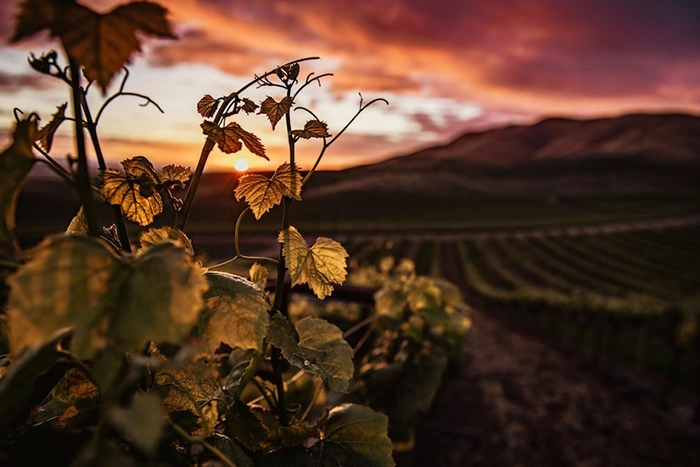
Now that the good weather is here and the daylight hours are lengthening, it is a good time to discover the island by taking short walks
Today we want to highlight a route of just 4 kilometers, which treasures important ethnographic, cultural and historical particularities of the north of Fuerteventura. The trail connects the town of Los Molinos with Playa de Jarugo.
Route: Los Molinos beach - Jarugo beach
The path that connects the beaches of Los Molinos and Jarugo is wide enough to be covered by bike. This option will be the best on hot days
Starting the route: Los Molinos
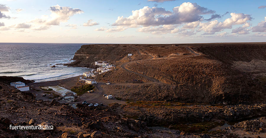
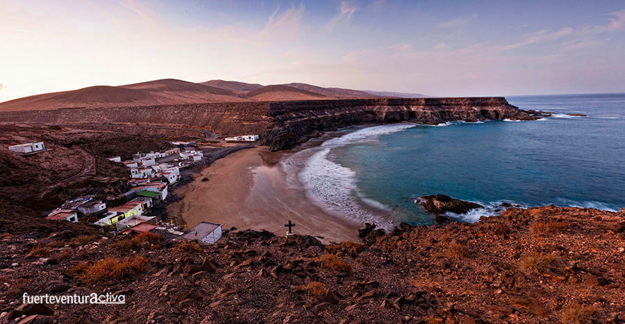
El Puertito de los Molinos is a small hamlet belonging to the municipality of Puerto del Rosario. It is located on the western slope of the island. It has a few houses, which were built by hand, on the shores of the wild ocean. High rocky escarpments protect this settlement from the strong prevailing winds that hit this part of the island.
Despite the fact that Los Molinos is permanently inhabited by a dozen neighbors, during the weekends and summer times it is full of tourists and majoreros. Keep it in mind if you come on the weekend.
At the entrance to Los Molinos there is an esplanade where you can park your vehicle. As soon as you get out of the car you will see the Casa Pon Restaurant. Well, to the right of the restaurant there is a dirt track that goes uphill. take it The climb does not last long, less than 5 minutes.
The first elements of ethnographic value that you will find on the way are the lime ovens. These structures are part of a flourishing past.
From the beginning of the 19th century until well into the 20th, the lime industry became one of the most important economic engines in Fuerteventura. From the Puertito de los Molinos tons of lime stones were shipped to other ports. Several kilns were also built, whose structures with a circular floor plan and frustoconical development are still preserved.
Once you have overcome the slope, an immense plain will open up before your eyes. We are facing the Llanos de los Opares and the Llanos de la Predrera.
Touring the Llanos de los Opares and La Predrera.
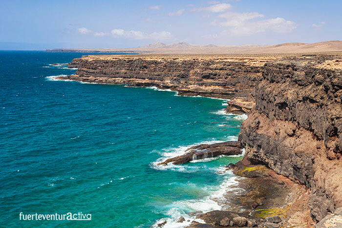
The widest track, suitable for 4x4 vehicles, heads to the right, then turns left across the arid plain. If you take it, you will also reach Jarugo beach, but you will miss the spectacular coastal landscape. For this reason, we suggest that you look for any of the multiple paths that border the coastal cliff, and walk along it with caution. La Cresta, Los Opares and Punta del Salvaje are the three most outstanding ledges of the first section. Approaching them is to lean out of wonderful balconies with privileged views towards the southwest of Fuerteventura. On clear days you can even see the Cofete arch. The plain also has its charm. It is marked by remains of aboriginal settlements. The mahos inhabited this plain. Here they found pasture for their goat herd and enough water to supply themselves.
From Punta del Salvaje to Jarugo.
Once past the Punta del Salvaje we will only visualize the north coast. It is possible to observe some intrepid fishermen, dressed with long rods, walking along the shore of the bay of the Salvaje looking for the best spot to fish. However, the rough waters, the strong wind and the waves make the area not suitable for swimming. La Punta del Salvaje hosts a large amount of marine fauna. Groupers, moray eels, old and white bream, are the pieces most valued by fishermen. The next landmark is Gambuesa de Jarugo, located 500 meters from our goal: Jarugo beach.
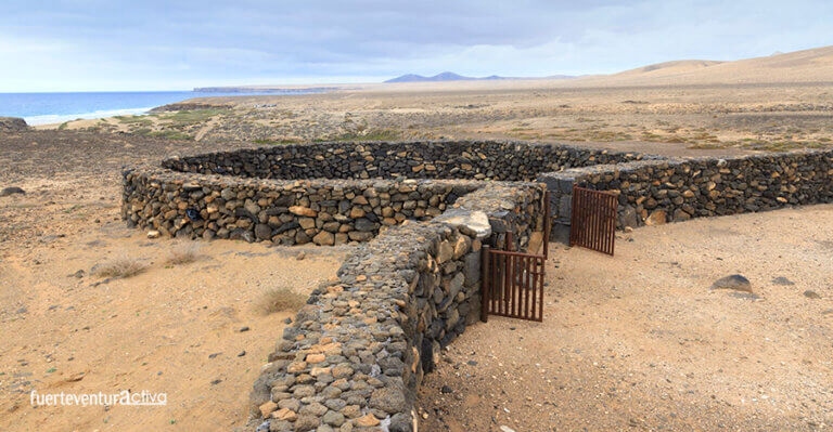
What is a Gambuesa?
Gambuesas are circular livestock structures. They are built with masonry and can exceed 2 meters in height. They consist of a larger corral and others, smaller, adjacent. Gambuesas are of pre-Hispanic origin and today they are still used for the same use for which they were built. In them the goats gathered in an apañada are enclosed. The objectives of the apañadas are diverse: check the state of the cattle, stock up on meat, mark new specimens, castrate male goats, goddaughter, take specimens for the domestic herds, the sale of baifos, etc. This tradition has been carried out since the origins of the Majorera culture, being a common activity for the primitive “majos”, which is how the ancient inhabitants of Lanzarote and Fuerteventura are known before their conquest by the Europeans.
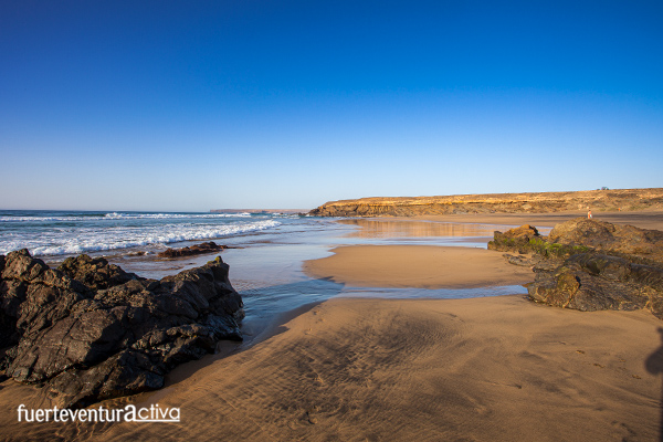
End of the journey: Jarugo beach
The beach forms an open cove surrounded by small cliffs, which in addition to giving it great beauty, protect it from the prevailing winds. In Jarugo you have about 250 meters long and 40 meters wide of fine sand beach to accommodate you and walk freely.
What fauna can be seen on the Playa de Los Molinos - Playa de Jarugo route?
Although the height of the coastline is low, and its extension is limited, these coastal cliffs bring together a varied and highly interesting fauna. The presence of birds of prey such as the guirre, the Barbary falcon and the common kestrel stands out. Also the Cory's Shearwater, the Macaronesian Shearwater and the Little Shearwater usually inhabit rocky areas. In the nearby plain, there are steppe birds, such as the houbaras, ortegas gangas or curlews, which roam freely in the area.
Information of interest Route 7: Jarugo - Los Molinos.
 El Puertito de los Molinos is a small hamlet belonging to the municipality of Puerto del Rosario. It is located on the western slope of the island. It has a few houses, which were built by hand, on the shores of the wild ocean. High rocky escarpments protect this settlement from the strong prevailing winds that hit this part of the island.
Despite the fact that Los Molinos is permanently inhabited by a dozen neighbors, during the weekends and summer times it is full of tourists and majoreros. Keep it in mind if you come on the weekend.
At the entrance to Los Molinos there is an esplanade where you can park your vehicle. As soon as you get out of the car you will see the Casa Pon Restaurant. Well, to the right of the restaurant there is a dirt track that goes uphill. take it The climb does not last long, less than 5 minutes.
The first elements of ethnographic value that you will find on the way are the lime ovens. These structures are part of a flourishing past.
From the beginning of the 19th century until well into the 20th, the lime industry became one of the most important economic engines in Fuerteventura. From the Puertito de los Molinos tons of lime stones were shipped to other ports. Several kilns were also built, whose structures with a circular floor plan and frustoconical development are still preserved.
Once you have overcome the slope, an immense plain will open up before your eyes. We are facing the Llanos de los Opares and the Llanos de la Predrera.
El Puertito de los Molinos is a small hamlet belonging to the municipality of Puerto del Rosario. It is located on the western slope of the island. It has a few houses, which were built by hand, on the shores of the wild ocean. High rocky escarpments protect this settlement from the strong prevailing winds that hit this part of the island.
Despite the fact that Los Molinos is permanently inhabited by a dozen neighbors, during the weekends and summer times it is full of tourists and majoreros. Keep it in mind if you come on the weekend.
At the entrance to Los Molinos there is an esplanade where you can park your vehicle. As soon as you get out of the car you will see the Casa Pon Restaurant. Well, to the right of the restaurant there is a dirt track that goes uphill. take it The climb does not last long, less than 5 minutes.
The first elements of ethnographic value that you will find on the way are the lime ovens. These structures are part of a flourishing past.
From the beginning of the 19th century until well into the 20th, the lime industry became one of the most important economic engines in Fuerteventura. From the Puertito de los Molinos tons of lime stones were shipped to other ports. Several kilns were also built, whose structures with a circular floor plan and frustoconical development are still preserved.
Once you have overcome the slope, an immense plain will open up before your eyes. We are facing the Llanos de los Opares and the Llanos de la Predrera.
 The widest track, suitable for 4x4 vehicles, heads to the right, then turns left across the arid plain. If you take it, you will also reach Jarugo beach, but you will miss the spectacular coastal landscape. For this reason, we suggest that you look for any of the multiple paths that border the coastal cliff, and walk along it with caution. La Cresta, Los Opares and Punta del Salvaje are the three most outstanding ledges of the first section. Approaching them is to lean out of wonderful balconies with privileged views towards the southwest of Fuerteventura. On clear days you can even see the Cofete arch. The plain also has its charm. It is marked by remains of aboriginal settlements. The mahos inhabited this plain. Here they found pasture for their goat herd and enough water to supply themselves.
 Once past the Punta del Salvaje we will only visualize the north coast. It is possible to observe some intrepid fishermen, dressed with long rods, walking along the shore of the bay of the Salvaje looking for the best spot to fish. However, the rough waters, the strong wind and the waves make the area not suitable for swimming. La Punta del Salvaje hosts a large amount of marine fauna. Groupers, moray eels, old and white bream, are the pieces most valued by fishermen. The next landmark is Gambuesa de Jarugo, located 500 meters from our goal: Jarugo beach.
 Gambuesas are circular livestock structures. They are built with masonry and can exceed 2 meters in height. They consist of a larger corral and others, smaller, adjacent. Gambuesas are of pre-Hispanic origin and today they are still used for the same use for which they were built. In them the goats gathered in an apañada are enclosed. The objectives of the apañadas are diverse: check the state of the cattle, stock up on meat, mark new specimens, castrate male goats, goddaughter, take specimens for the domestic herds, the sale of baifos, etc. This tradition has been carried out since the origins of the Majorera culture, being a common activity for the primitive “majos”, which is how the ancient inhabitants of Lanzarote and Fuerteventura are known before their conquest by the Europeans.
 The beach forms an open cove surrounded by small cliffs, which in addition to giving it great beauty, protect it from the prevailing winds. In Jarugo you have about 250 meters long and 40 meters wide of fine sand beach to accommodate you and walk freely.