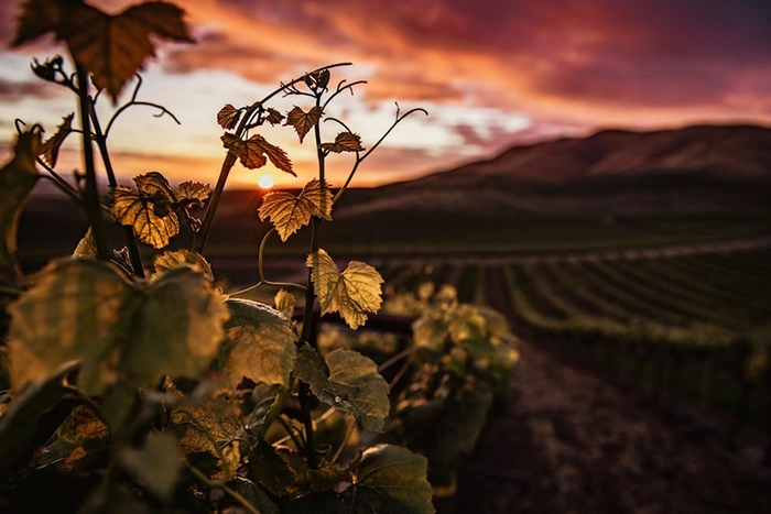
The Valley de la Cave is an arid place of great beauty. It is located in the center-east of Fuerteventura and belongs to the Natural Monument of the Cuchillos de Vigán.
Going through the Valle de la Cueva ravine from Tenicosquey is a beautiful experience of great interest for those who seek to know the intrahistory of our beloved Fuerteventura.
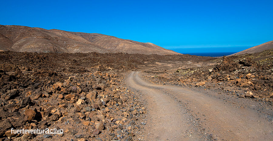
The difficulty of the route could be categorized as medium, not because there are obstacles or large slopes, but because you will travel through a wasteland that is sometimes monotonous. Don't let this stop you. The ride is worth it.
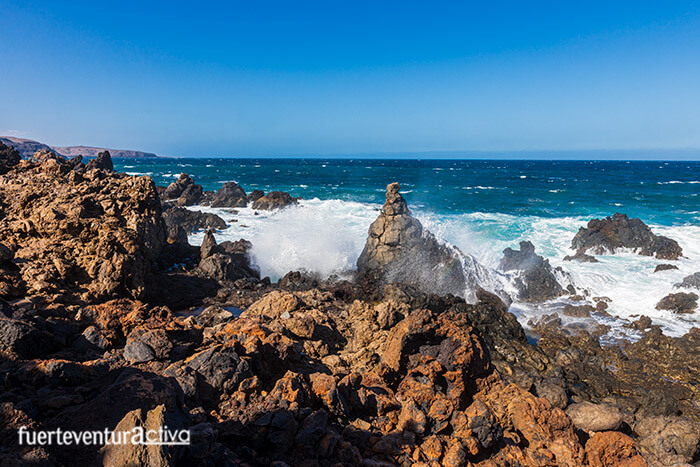
Among the most notable landmarks you will find on this route is an impressive and rugged coastline and an aboriginal settlement. This archaeological site is one of the oldest and most unknown in Fuerteventura.
Starting the route
The Valle de la Cueva ravine can be explored both on foot and by bike, it is also possible to visit it by off-road vehicle, quads, and buggys. But if you go for the latter option, you will miss out on mesmerizing panoramas.
If you have a free morning or afternoon, don't be lazy, put on your hiking boots and come for a walk.
To start the route you will have to get to Casas de Tenicosquey, a small settlement of just a dozen houses, located at km 30 of the FV-2 highway.
You can leave the vehicle at the Tenicosquey Cultural Center located on the Saladillo road.
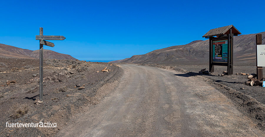
Get going and head east. A few meters from the cultural center there is a crossroads that indicates the direction to follow. Approximately one kilometer later, the track forks again. At the crossroads you will see a wooden sign showing directions to Jacomar and Valle de la Cueva. There is also a large sign with information about the route, the most representative plants and animals in the area.
Take the path to the left, the one that goes down towards the coast.
The Valle de la Cueva ravine extends through part of the volcanic flows from the Jacomar volcano. It runs parallel to the Juanichón mountain and the Toneles volcano on its right bank, and to the Cañada de Chamorro and Cuesta Chillona on its left bank. The ravine flows into the Ensenada de los Toneles.
Walking through the Valley of the Cave
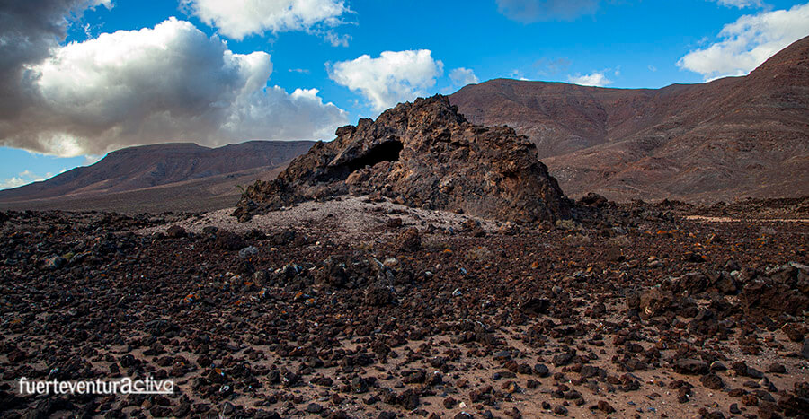
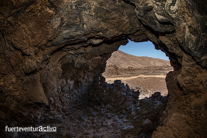
About 3 kilometers after the last crossroads, the badlands de los Toneles appears surprisingly in the Valle de la Cueva. In this badlands, the hornitos stand out: small holes through which the gases of the volcanic eruptions were released. Some of the hornitos have formed caves with vertical entrances.
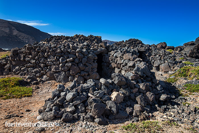
There are hornitos so large that they have been used by the inhabitants of Fuerteventura, since Pre-Hispanic times, as a home and a meeting point. One of them deserves special attention and a more detailed visit. They call it the Cathedral or the church. Inside it has several chambers 2.5 meters high and similar width. This oven is what gives the name to the valley.
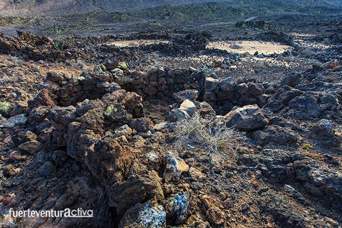
In the badlands, the mahos found a good place to establish their settlement.
The essential reason why the aborigines of Fuerteventura decided to build their homes, in this type of lava, is because it provided them with a perfect mimicry with the environment. Even being a few meters away it is difficult to see the houses. In addition, small lagoons form between the badlands when it rains, which are capable of retaining moisture for days, and even weeks.
That humidity was enough for the grass to grow, so fundamental in the maintenance of their extensive goat herd. The mahos who lived in the town of Malpaís de los Toneles dedicated themselves almost exclusively to goat farming, from which they obtained most of their daily food resources: meat, milk and fat. The diet was complemented with the intake of limpets, burgados, fish, and different molluscs that they obtained from shellfishing carried out on the nearby coast. Even after more than ten centuries have passed since the establishment of the majos in the Valle de la Cueva, it is still possible to see a great variety and quantity of shell remains in the town. Also ceramic on the surface.
The settlement of Malpaís de los Toneles dates from the III - IV century of our era. It is, therefore, one of the oldest on the island. It is made up of some 150 constructions with an oval or circular floor plan, of various sizes, made with dry stone (made without mortar). The materials with which the houses were built were taken from the immediate environment. The lava flows offered them an abundant and adequate construction material
Arriving at the coast
After a long walk through the Malpaís de los Toneles, it is time to continue along the route traveled mainly by the local population, fishermen and ranchers. In the environment the "coast goats" roam freely. Most of these goats will be collected in the gambuesa del Valle de la Cueva during the apañadas. That is one of the most ancient traditions of Fuerteventura.
La gambuesa is a few meters from the aboriginal settlement. From there to the beach it is only a 15-minute leisurely walk.
The coast is very wild and abrupt. It does not have any type of surveillance and lifeguard service. In addition, the telephone coverage does not arrive either, so take extreme precautions when you are there.
Our route for today ends here, but if you have been left wanting more, you can go to the Jacomar fishing refuge. You just have to go along one of the many paths that start from Ensenada de los Toneles to the right.
If you follow some brown and white landmarks of the DPMT (Public Maritime Terrestrial Domain) you will have no loss to get to Jacomar.
[ux_product_categories]
Fuerteventura2 Fuerteventura1
 Among the most notable landmarks you will find on this route is an impressive and rugged coastline and an aboriginal settlement. This archaeological site is one of the oldest and most unknown in Fuerteventura.
 Take the path to the left, the one that goes down towards the coast.
The Valle de la Cueva ravine extends through part of the volcanic flows from the Jacomar volcano. It runs parallel to the Juanichón mountain and the Toneles volcano on its right bank, and to the Cañada de Chamorro and Cuesta Chillona on its left bank. The ravine flows into the Ensenada de los Toneles.
Take the path to the left, the one that goes down towards the coast.
The Valle de la Cueva ravine extends through part of the volcanic flows from the Jacomar volcano. It runs parallel to the Juanichón mountain and the Toneles volcano on its right bank, and to the Cañada de Chamorro and Cuesta Chillona on its left bank. The ravine flows into the Ensenada de los Toneles.
 In the badlands, the mahos found a good place to establish their settlement.
The essential reason why the aborigines of Fuerteventura decided to build their homes, in this type of lava, is because it provided them with a perfect mimicry with the environment. Even being a few meters away it is difficult to see the houses. In addition, small lagoons form between the badlands when it rains, which are capable of retaining moisture for days, and even weeks.
In the badlands, the mahos found a good place to establish their settlement.
The essential reason why the aborigines of Fuerteventura decided to build their homes, in this type of lava, is because it provided them with a perfect mimicry with the environment. Even being a few meters away it is difficult to see the houses. In addition, small lagoons form between the badlands when it rains, which are capable of retaining moisture for days, and even weeks.
 That humidity was enough for the grass to grow, so fundamental in the maintenance of their extensive goat herd. The mahos who lived in the town of Malpaís de los Toneles dedicated themselves almost exclusively to goat farming, from which they obtained most of their daily food resources: meat, milk and fat. The diet was complemented with the intake of limpets, burgados, fish, and different molluscs that they obtained from shellfishing carried out on the nearby coast. Even after more than ten centuries have passed since the establishment of the majos in the Valle de la Cueva, it is still possible to see a great variety and quantity of shell remains in the town. Also ceramic on the surface.
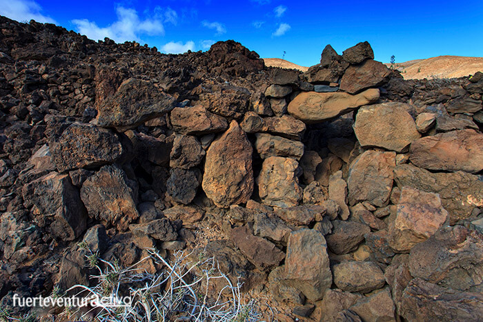 The settlement of Malpaís de los Toneles dates from the III - IV century of our era. It is, therefore, one of the oldest on the island. It is made up of some 150 constructions with an oval or circular floor plan, of various sizes, made with dry stone (made without mortar). The materials with which the houses were built were taken from the immediate environment. The lava flows offered them an abundant and adequate construction material
 After a long walk through the Malpaís de los Toneles, it is time to continue along the route traveled mainly by the local population, fishermen and ranchers. In the environment the "coast goats" roam freely. Most of these goats will be collected in the gambuesa del Valle de la Cueva during the apañadas. That is one of the most ancient traditions of Fuerteventura.
 La gambuesa is a few meters from the aboriginal settlement. From there to the beach it is only a 15-minute leisurely walk.
The coast is very wild and abrupt. It does not have any type of surveillance and lifeguard service. In addition, the telephone coverage does not arrive either, so take extreme precautions when you are there.
Our route for today ends here, but if you have been left wanting more, you can go to the Jacomar fishing refuge. You just have to go along one of the many paths that start from Ensenada de los Toneles to the right.
La gambuesa is a few meters from the aboriginal settlement. From there to the beach it is only a 15-minute leisurely walk.
The coast is very wild and abrupt. It does not have any type of surveillance and lifeguard service. In addition, the telephone coverage does not arrive either, so take extreme precautions when you are there.
Our route for today ends here, but if you have been left wanting more, you can go to the Jacomar fishing refuge. You just have to go along one of the many paths that start from Ensenada de los Toneles to the right.