One of the greatest attractions of the north of Fuerteventura is that you can leave the vehicle relatively close to your goal and discover charming places in just a few minutes. Going to the municipality of La Oliva and walking through one of its many paths, is something we like to do when we have free time.
Today we will do one of the most spectacular hikes to do in the town of Villaverde: de Montaña de la Arena circular trail.
Montaña de la Arena
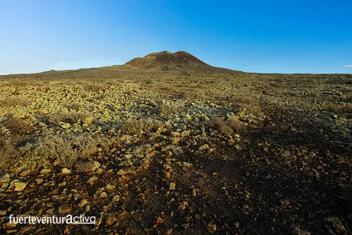
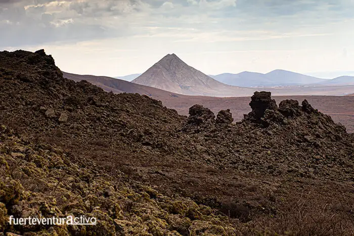
The Montaña de la Arena is one of the most important volcanic cones in Villaverde. It gives its name to the badlands that surround it. It has an ellipsoidal plan, 760 meters long by 510 meters wide. It has two craters. Its altitude, from the base of the cone, is about 120 meters, placing its top at 420 meters above sea level.
At the foot of Montaña de la Arena, a plain of undulating lands opens up, invaded by the lavas that emerged from its interior about 138,000 years ago. The Montaña de la Arena volcano is considered one of the youngest on the island.
Malpaís de la Arena monument
The identity of a good part of Villaverde is linked to volcanic cones, chimneys and craters. In short, the badlands, a territory of petrified lava, in which a drop of water is a real treasure.
This rugged, wasteland and agriculturally unproductive land is set to become a great tourist attraction, and therefore, an economic booster. The Malpaís de la Arena Monument has all the ingredients to be part of it. It offers a mixture of beautiful landscapes and great biological biodiversity.
The eruptive activity that took place in Villaverde for thousands of years has formed the Malpaís de la Arena Natural Monument. This lava space occupies about 12 square kilometers, extending from Lajares to La Oliva.
In this landscape dominated by the Arena volcano, there are numerous caves that were once occupied, both in pre-Hispanic times and after the Franco-Norman conquest. These include the Cueva de los Ídolos, the Cueva de los Picos, the Cueva del Diablo, etc.
One of the enclaves that arouse the most interest, at an archaeological level, in the Malpaís de la Arena, are the so-called "Suns of Tejate", made up of circular and ovoid structures, which some identify as astronomical observation points of the mahos.
Circular route through the Montaña de la Arena.
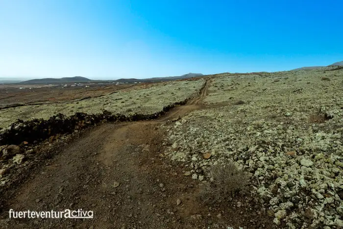
The route that borders the Montaña de la Arena volcano connects, in part, with Stage 2 of the GR (Great Route) -131.
Its natural beauty lies both in the possibility of walking through the badlands, and in the fact of being able to discover the most authentic flora and fauna of Fuerteventura.
Among the plant species that we will see at our feet, are: the bitter tabaiba, populations of cuernúa, (a species protected by regional regulations), asparagus majorera, piteras, cosco, orchilla, scan, and important populations of taxica.
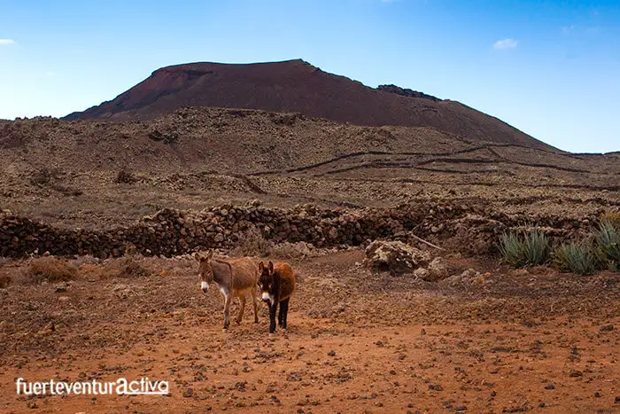
In addition, the space that surrounds Montaña de la Arena becomes an important point for ornithological observation. The guirre, the Canary crow, the hawk and the kestrel, inhabit in perfect harmony with other smaller birds such as the Canary stonebird, the shrike, and the trumpeter bullfinch, among other species. It is also easy to spot owls.
You have to be very careful when entering the Malpaís de la Arena between the months of May and September. This is an area where shearwaters nest and seek refuge in their breeding season.
Inside the badlands you can see several jameos and "hornitos", small holes through which gases from volcanic eruptions were released, some of them of such a size that they allowed their use as living space.
Where is the start of the route to Montaña de la Arena?
The end of Montaña de la Arena street is a good place to start this route that will take you to a magical enclave, one of those places that has the virtue of disconnecting you from the real world and transporting you to another of peace, in just a few minutes.
Although, a priori, it may seem difficult to find the street due to the maze of alleys in this part of Villaverde, it really is not. However, here we leave you the link to Google maps where you can leave the vehicle and start walking.
How long does it take to do the route?
The route that borders the Montaña de la Arena, has a length of about 8.5 kilometers. It takes between 3 hours and 3 and a half hours to cross it.
Is it difficult to do the Arena Mountain Circular route?
This route does not involve great technical difficulties. However, it is advisable to be used to a minimum of sports practice and to orient yourself well in the mountains. Some parts of the route are not signposted.
Using applications like Wikiloc will help you get on the right track.
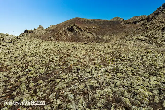
Is it possible to climb the crater of Montaña de la Arena?
Public institutions have not enabled any path that allows you to climb to the crown of Montaña de la Arena.
The slopes of this volcanic cone have been exploited centuries ago as a picón quarry. Until almost its top there is an old track, belonging to the quarry, which we do not recommend taking, as it is private property and entails a certain danger of landslides .
[ux_product_categories]
Fuerteventura2
 In this landscape dominated by the Arena volcano, there are numerous caves that were once occupied, both in pre-Hispanic times and after the Franco-Norman conquest. These include the Cueva de los Ídolos, the Cueva de los Picos, the Cueva del Diablo, etc.
One of the enclaves that arouse the most interest, at an archaeological level, in the Malpaís de la Arena, are the so-called "Suns of Tejate", made up of circular and ovoid structures, which some identify as astronomical observation points of the mahos.
In this landscape dominated by the Arena volcano, there are numerous caves that were once occupied, both in pre-Hispanic times and after the Franco-Norman conquest. These include the Cueva de los Ídolos, the Cueva de los Picos, the Cueva del Diablo, etc.
One of the enclaves that arouse the most interest, at an archaeological level, in the Malpaís de la Arena, are the so-called "Suns of Tejate", made up of circular and ovoid structures, which some identify as astronomical observation points of the mahos.
 The route that borders the Montaña de la Arena volcano connects, in part, with Stage 2 of the GR (Great Route) -131.
Its natural beauty lies both in the possibility of walking through the badlands, and in the fact of being able to discover the most authentic flora and fauna of Fuerteventura.
Among the plant species that we will see at our feet, are: the bitter tabaiba, populations of cuernúa, (a species protected by regional regulations), asparagus majorera, piteras, cosco, orchilla, scan, and important populations of taxica.
In addition, the space that surrounds Montaña de la Arena becomes an important point for ornithological observation. The guirre, the Canary crow, the hawk and the kestrel, inhabit in perfect harmony with other smaller birds such as the Canary stonebird, the shrike, and the trumpeter bullfinch, among other species. It is also easy to spot owls.
The route that borders the Montaña de la Arena volcano connects, in part, with Stage 2 of the GR (Great Route) -131.
Its natural beauty lies both in the possibility of walking through the badlands, and in the fact of being able to discover the most authentic flora and fauna of Fuerteventura.
Among the plant species that we will see at our feet, are: the bitter tabaiba, populations of cuernúa, (a species protected by regional regulations), asparagus majorera, piteras, cosco, orchilla, scan, and important populations of taxica.
In addition, the space that surrounds Montaña de la Arena becomes an important point for ornithological observation. The guirre, the Canary crow, the hawk and the kestrel, inhabit in perfect harmony with other smaller birds such as the Canary stonebird, the shrike, and the trumpeter bullfinch, among other species. It is also easy to spot owls.
 You have to be very careful when entering the Malpaís de la Arena between the months of May and September. This is an area where shearwaters nest and seek refuge in their breeding season.
Inside the badlands you can see several jameos and "hornitos", small holes through which gases from volcanic eruptions were released, some of them of such a size that they allowed their use as living space.
You have to be very careful when entering the Malpaís de la Arena between the months of May and September. This is an area where shearwaters nest and seek refuge in their breeding season.
Inside the badlands you can see several jameos and "hornitos", small holes through which gases from volcanic eruptions were released, some of them of such a size that they allowed their use as living space.