The hiking route that we propose today runs between two historic hermitages: San Agustín in Tefía and San Andrés in Tetir. It is a variation of the PR FV-15 trail.
Fuerteventura gives you, throughout this journey, a rugged landscape that seems to have remained anchored in another time, at that time when Fuerteventura smelled of parva, threshing and cereal. When the island's mills would not stop turning, thanks to the trade winds.
Before starting the route we want to point out that this is one of the so-called historic roads. It has been traveled throughout history by thousands of majoreros. It was one of the most direct and fastest paths, which existed in the past, to go from Tefía to Tetir.
Start of the Route: Hermitage of San Agustín
The starting point is also a good place to leave the vehicle: the hermitage of San Agustín, in Tefía.
Here we leave you the link of the Googlemaps.
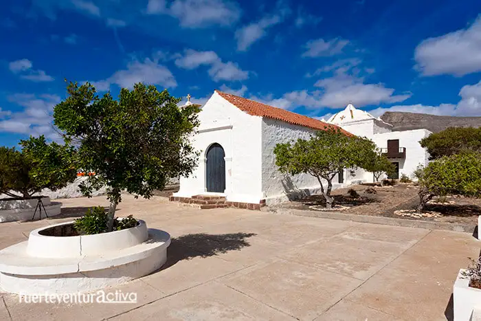
The small and modest sanctuary of Tefía dates from the beginning of the 18th century. It has been remodeled several times. At first, the hermitage was open to the field. It consisted of a single nave with a gabled roof. Later, the barbican (outer wall) was added to prevent the passage of cattle, also the two-storey sacristy and a chapel covered by a false octagonal dome.
After a slight look at the hermitage, we enter the dirt road towards the east, towards the mountains, leaving the temple of Tefía behind us. The first kilometer and a half of this path runs along the borders of agricultural estates, on whose walls we can find, if we are not in a hurry, petroglyphs. Some of these are game boards, including cedar checkerboards and chasconas.
These walls were made a long time ago and, to build them, they used everything that was close to them. Possibly many masons come from some nearby aboriginal habitat.
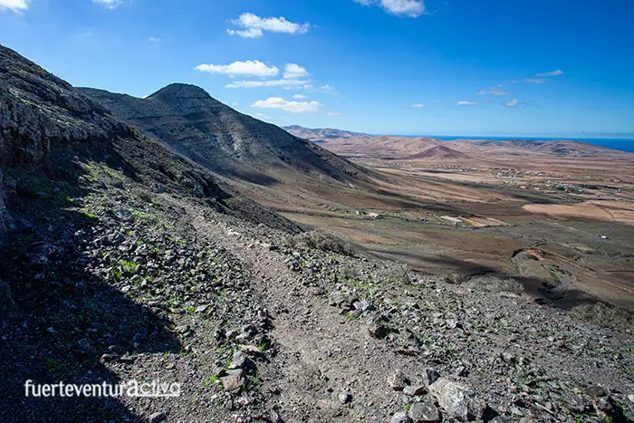
After the first kilometer and a half, the path becomes narrower and steeper. You can see that we are going up towards the Degollada de Facay.
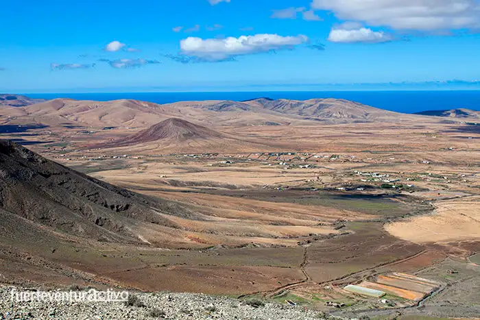
During approximately 2 kilometers of ascent we will be able to enjoy extraordinary views of the foothills of the Facay Mountain, the town of Tefía and its surroundings. It stands out above all Montaña Bermeja, which stands alone on the extensive plain.
The vegetation that we find, during this part of the route, is mainly made up of greens, wild tabaibas and gorse. In addition, the place is the perfect habitat for the most emblematic raptors of Fuerteventura, such as the guirre, the common kestrel and the common buzzard. The light-edged bat is also often seen at sunset.
There are only a few meters left to reach the Facay throat.
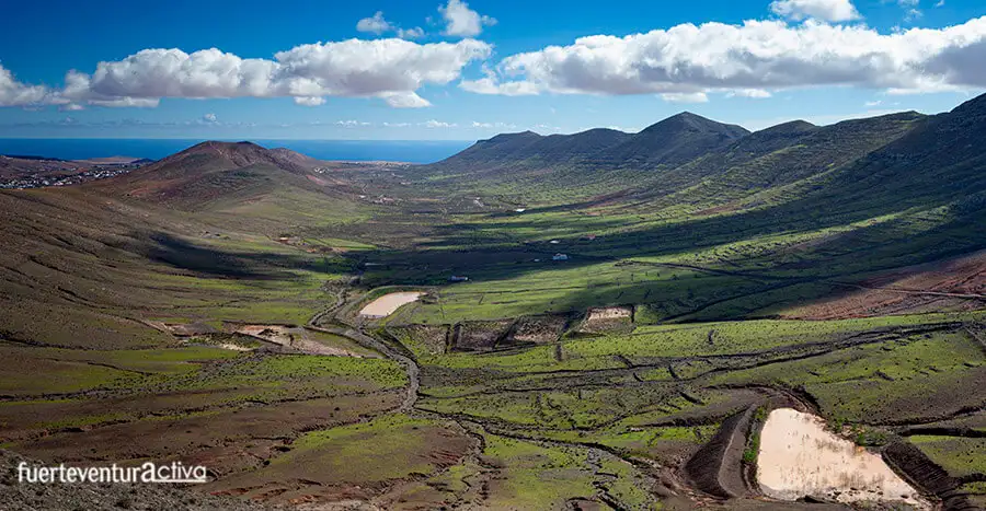
La degollada is an ideal enclave to contemplate the two slopes of this mountain range that runs parallel to the coast. Towards the east, the entire Vega de Tetir is dominated, a set of gavias, nateros and crops. While the west is dominated by the most arid terrain.
Here we will take a well-deserved rest, we will regain strength and we will review some historical data.
This area was very significant for the aboriginal world. In fact, the name of Facay or Afacay alludes to some important personage who lived, in the place, before the Franco-Norman conquest. The place name has remained unchanged for centuries.
The name of one of his daughters, “Iján”, has also transcended to this day, since that is the name of the nearby source that supplied the Facay family. Once we have rested, we continue the road to the fertile plain of Tetir, considered one of the most fertile lands in Fuerteventura.
The trail descends gently, through the valley. It runs parallel to the last foothills of the central knife system. The most important peaks that we will see on our right are the Pico de La Fortaleza, Morro de La Galera, Morro de La Atalaya and Morro de Las Piteras. In just 40 minutes, from the throat of Facay, we will be at the foot of the San Andrés mountain, in front of the homonymous hermitage.
End of route: Hermitage of San Andrés
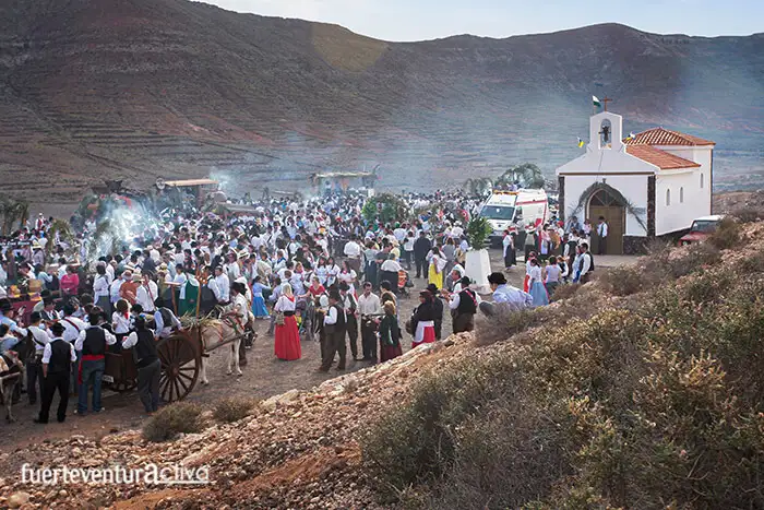
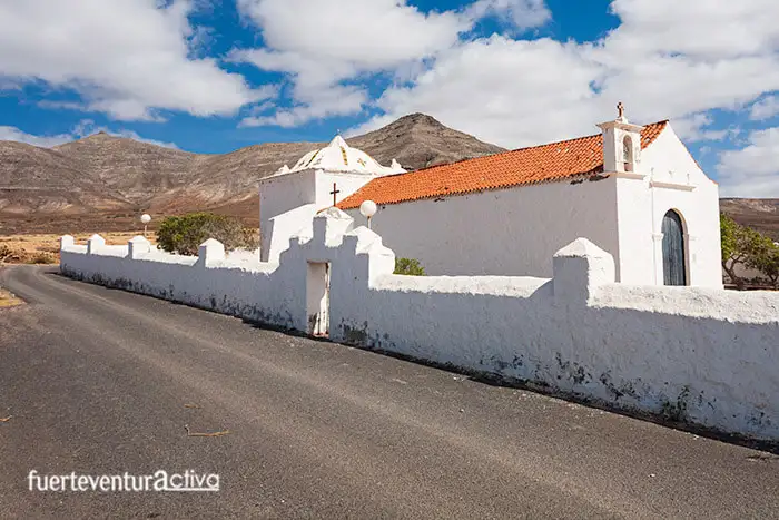
The hermitage of San Andrés has been rebuilt only a few decades ago. This modern construction cannot make us forget that here was the first sanctuary of the Vega de Tetir, erected in 1652. Every November 30 thousands of pilgrims gather at the hermitage. They accompany the saint in a procession through the streets of Tetir to the Plaza de Juan Rodríguez y González.
How far and how long does it take to make the route from San Agustín to San Andrés?
Although the route is just under 8 kilometers, it takes just over 2 hours to complete it. Calculate round trip 5 hours.
What difficulty do you have?
The route does not have technical or orientation difficulties. However, the climb to Degollada de Facay is quite steep. This makes the tour not suitable for all physical conditions. We would say that it has a medium difficulty.
Are there options to return to the departure point by public transport?
If you have decided to do this route approaching in a single private vehicle to the hermitage of Tefía, and you cannot walk back, you will have to make two trips by guagua (bus). First from Tetir to Puerto del Rosario, on line 07. And then, take line 02 (Puerto del Rosario-Vegas del Río Palmas) that will leave you in Tefía, about 500 meters from the hermitage of San Agustín.
GPX routeRoute in Google Earth Route in PDF
[ux_product_categories]
Fuerteventura2
 The starting point is also a good place to leave the vehicle: the hermitage of San Agustín, in Tefía.
Here we leave you the link of the Googlemaps.
The small and modest sanctuary of Tefía dates from the beginning of the 18th century. It has been remodeled several times. At first, the hermitage was open to the field. It consisted of a single nave with a gabled roof. Later, the barbican (outer wall) was added to prevent the passage of cattle, also the two-storey sacristy and a chapel covered by a false octagonal dome.
After a slight look at the hermitage, we enter the dirt road towards the east, towards the mountains, leaving the temple of Tefía behind us. The first kilometer and a half of this path runs along the borders of agricultural estates, on whose walls we can find, if we are not in a hurry, petroglyphs. Some of these are game boards, including cedar checkerboards and chasconas.
These walls were made a long time ago and, to build them, they used everything that was close to them. Possibly many masons come from some nearby aboriginal habitat.
The starting point is also a good place to leave the vehicle: the hermitage of San Agustín, in Tefía.
Here we leave you the link of the Googlemaps.
The small and modest sanctuary of Tefía dates from the beginning of the 18th century. It has been remodeled several times. At first, the hermitage was open to the field. It consisted of a single nave with a gabled roof. Later, the barbican (outer wall) was added to prevent the passage of cattle, also the two-storey sacristy and a chapel covered by a false octagonal dome.
After a slight look at the hermitage, we enter the dirt road towards the east, towards the mountains, leaving the temple of Tefía behind us. The first kilometer and a half of this path runs along the borders of agricultural estates, on whose walls we can find, if we are not in a hurry, petroglyphs. Some of these are game boards, including cedar checkerboards and chasconas.
These walls were made a long time ago and, to build them, they used everything that was close to them. Possibly many masons come from some nearby aboriginal habitat.
 After the first kilometer and a half, the path becomes narrower and steeper. You can see that we are going up towards the Degollada de Facay.
During approximately 2 kilometers of ascent we will be able to enjoy extraordinary views of the foothills of the Facay Mountain, the town of Tefía and its surroundings. It stands out above all Montaña Bermeja, which stands alone on the extensive plain.
After the first kilometer and a half, the path becomes narrower and steeper. You can see that we are going up towards the Degollada de Facay.
During approximately 2 kilometers of ascent we will be able to enjoy extraordinary views of the foothills of the Facay Mountain, the town of Tefía and its surroundings. It stands out above all Montaña Bermeja, which stands alone on the extensive plain.
 The vegetation that we find, during this part of the route, is mainly made up of greens, wild tabaibas and gorse. In addition, the place is the perfect habitat for the most emblematic raptors of Fuerteventura, such as the guirre, the common kestrel and the common buzzard. The light-edged bat is also often seen at sunset.
There are only a few meters left to reach the Facay throat.
La degollada is an ideal enclave to contemplate the two slopes of this mountain range that runs parallel to the coast. Towards the east, the entire Vega de Tetir is dominated, a set of gavias, nateros and crops. While the west is dominated by the most arid terrain.
Here we will take a well-deserved rest, we will regain strength and we will review some historical data.
The vegetation that we find, during this part of the route, is mainly made up of greens, wild tabaibas and gorse. In addition, the place is the perfect habitat for the most emblematic raptors of Fuerteventura, such as the guirre, the common kestrel and the common buzzard. The light-edged bat is also often seen at sunset.
There are only a few meters left to reach the Facay throat.
La degollada is an ideal enclave to contemplate the two slopes of this mountain range that runs parallel to the coast. Towards the east, the entire Vega de Tetir is dominated, a set of gavias, nateros and crops. While the west is dominated by the most arid terrain.
Here we will take a well-deserved rest, we will regain strength and we will review some historical data.
 This area was very significant for the aboriginal world. In fact, the name of Facay or Afacay alludes to some important personage who lived, in the place, before the Franco-Norman conquest. The place name has remained unchanged for centuries.
The name of one of his daughters, “Iján”, has also transcended to this day, since that is the name of the nearby source that supplied the Facay family. Once we have rested, we continue the road to the fertile plain of Tetir, considered one of the most fertile lands in Fuerteventura.
This area was very significant for the aboriginal world. In fact, the name of Facay or Afacay alludes to some important personage who lived, in the place, before the Franco-Norman conquest. The place name has remained unchanged for centuries.
The name of one of his daughters, “Iján”, has also transcended to this day, since that is the name of the nearby source that supplied the Facay family. Once we have rested, we continue the road to the fertile plain of Tetir, considered one of the most fertile lands in Fuerteventura.
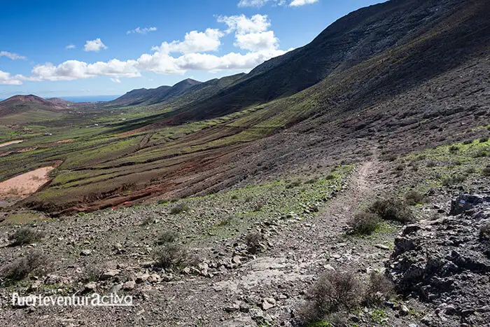 The trail descends gently, through the valley. It runs parallel to the last foothills of the central knife system. The most important peaks that we will see on our right are the Pico de La Fortaleza, Morro de La Galera, Morro de La Atalaya and Morro de Las Piteras. In just 40 minutes, from the throat of Facay, we will be at the foot of the San Andrés mountain, in front of the homonymous hermitage.